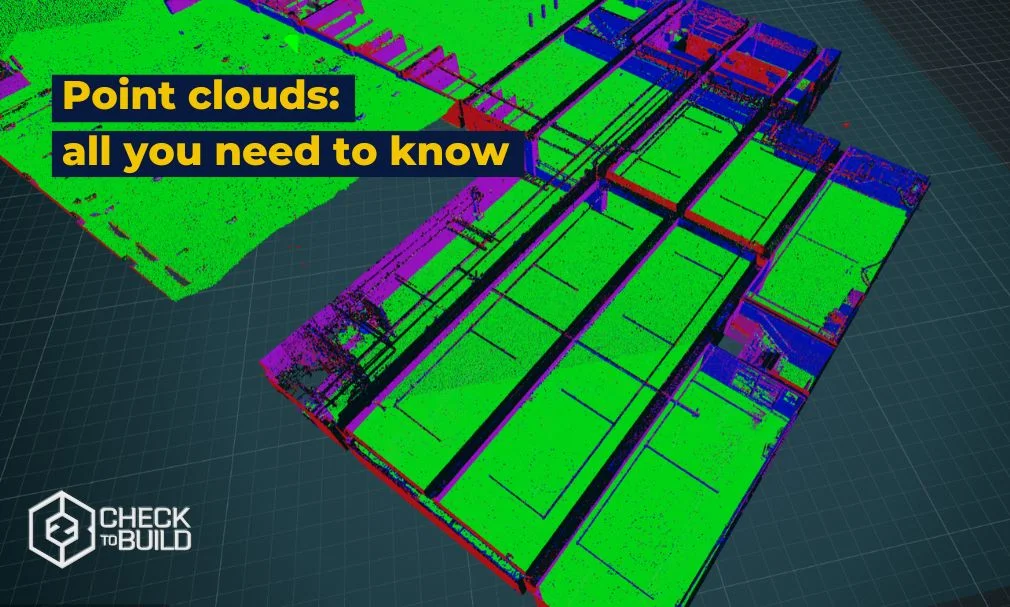
Point clouds have exploded onto the construction industry, offering a revolutionary solution for capturing and analyzing three-dimensional data. With their ability to create accurate and detailed models of sites and structures, point clouds are changing the way construction projects are planned, designed and executed.
This innovative technology brings new levels of efficiency and accuracy. It helps reduce risks, enhances collaboration, and can significantly cut costs on-site. Let’s explore how point clouds work and why they are becoming so essential for construction.
What is a point cloud?
Point clouds actively represent objects, environments, or surfaces in three dimensions by combining millions of spatial points into a cohesive digital model. Technologies such as laser scanning, terrestrial scanning, and photogrammetry capture these points by mapping their positions and coordinates relative to a defined reference system.
Each point in a cloud contains essential spatial data and, sometimes, additional attributes like color or intensity, which enrich the dataset. When these points are aggregated, they form a detailed and precise 3D representation, making the scanned object or environment suitable for visualization, analysis, and manipulation in virtual environments or specialized software.
Professionals across industries—including architecture, engineering, construction, mapping, and heritage conservation—leverage point clouds for their unparalleled ability to deliver highly accurate 3D data. This accuracy drives improved project planning, design validation, and progress monitoring.
How point clouds are classified
Point cloud data captures precise three-dimensional details of objects and environments using advanced 3D scanning technologies. These techniques collect spatial and geometric information essential for creating accurate digital models. Key technologies for obtaining point cloud data include:
- Terrestrial laser scanning (TLS): Terrestrial laser scanning uses a laser scanner mounted on a tripod or vehicle to emit laser pulses. By measuring the time it takes for the reflected pulses to return, this technique calculates distances to surrounding objects. Scanning extensive areas and combining multiple scans generate detailed 3D point clouds, making TLS ideal for capturing complex environments.
- Terrestrial photogrammetry: Photogrammetry employs photographs taken from various angles to determine the 3D geometry of objects or environments. Specialized algorithms match features across multiple images to extract 3D points, producing comprehensive point clouds. This method excels in projects requiring visual and spatial detail from multiple perspectives.
- Airborne laser scanning (ALS): Mounted on aircraft or drones, airborne laser scanners emit laser pulses toward the ground. These pulses reflect back to the scanner, capturing terrain and object data from above. ALS delivers high-resolution point clouds over large areas, perfect for topographic mapping and large-scale construction projects.
- Structured light scanning: Structured light scanning projects patterns, such as lines or dots, onto objects. Cameras record the deformation of the light caused by the object’s geometry. This data is analyzed to generate 3D points, making it an excellent choice for capturing fine details and precise dimensions.
- Sensor-based capture: Specialized sensors like Time-of-Flight (ToF) measure the time light pulses take to reflect back, calculating distances to form point clouds. ToF sensors are compact and versatile, suitable for various applications, from industrial inspections to architectural modeling.
These are just some of the most common technologies used to obtain point cloud data. Each has its own advantages and technical considerations, so the choice of technique depends on the specific application and project requirements.
Converting point clouds to 3D mesh models
Point cloud to mesh is the process of converting a point cloud into a three-dimensional mesh. These points are obtained by 3D scanning techniques, such as laser scanning or photogrammetry, and contain information about the shape, position and density of the scanned objects.
The conversion of a point cloud into a three-dimensional mesh involves the creation of a solid and continuous surface structure that resembles the objects represented by the points. A three-dimensional mesh is composed of vertices (points in three-dimensional space), edges (connections between vertices) and faces (surfaces formed by the edges).
This process involves using algorithms and techniques to reconstruct the underlying geometry from the points in the cloud. These algorithms can perform operations such as triangulation or fitting parametric or implicit surfaces to the points to create a smoother and more accurate representation of the object.
Key steps in this conversion include:
- Point Cloud Registration: Aligning and merging individual point clouds into a cohesive dataset using algorithms like Iterative Closest Point (ICP).
- Triangulation: Generating a mesh by connecting nearby points into triangles for better visualization.
- Data Cleaning: Filtering out noise and redundant data to ensure accuracy.
- Optimization: Refining the mesh for smoother surfaces and reducing file size.
This transformation is crucial for applications like BIM integration, where precise models are essential
Enhancing point clouds with deep learning
Deep learning is revolutionizing how we process and analyze point cloud data. By training AI models on large datasets, construction professionals can:
- Automate Object Detection: Identify features such as pipes, walls, or equipment within the point cloud.
- Streamline Classification: Group points into categories like terrain, vegetation, or structural elements.
- Predict Future Conditions: Use historical data to forecast structural wear or project risks.
Integrating deep learning with point clouds enables faster analysis and more actionable insights, saving time and reducing human error.
Applications of point clouds in construction
Point clouds play a pivotal role throughout the construction lifecycle:
- Design validation: Ensure designs align with on-site realities by comparing BIM models with point cloud data.
- Progress monitoring: Track construction progress with regular scans to identify deviations early.
- Digital Twins: Create dynamic, up-to-date digital representations of physical assets for real-time management.
- Risk Mitigation: Detect potential issues, such as clashes or misalignments, before they escalate.
By providing accurate, real-time insights, point clouds improve decision-making and project outcomes.
The future of point clouds in construction
The integration of point clouds with technologies like deep learning and advanced BIM tools is shaping the future of construction. As AI and automation become more sophisticated, point clouds will continue to drive innovation, delivering unparalleled efficiency and precision.
For construction firms looking to stay competitive, adopting point cloud technology is no longer optional—it’s essential. By leveraging its capabilities, companies can achieve smarter, safer, and more sustainable projects.
Do you want to know more about C2B Platform? Request a demo
Share this article:
Related Articles